Use graphics.py. It is a simple graphics library.
Click HERE
 for more information.
(download, install, documentation, ...)
for more information.
(download, install, documentation, ...)
Project #1:
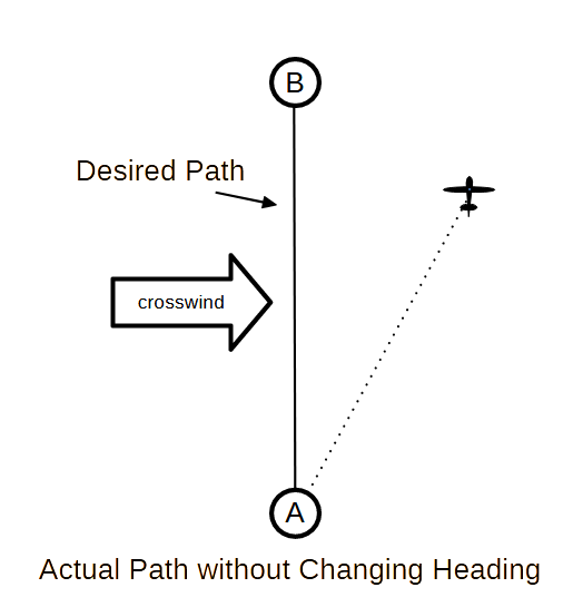
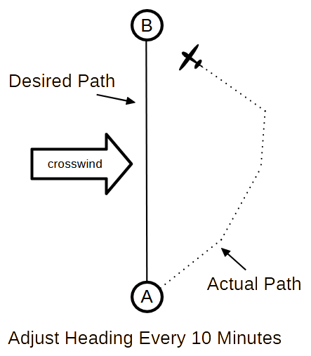
Create an interactive program that plots an airplane's path from from airport A to B (see assumptions).
At takeoff from airport A the airplane is pointed directly at airport B. It maintains this heading for 10 minutes and then modifies the heading (if necessary) to again point at airport B. This continues until reaching airport B.
Plot the airplane's location every 10 minutes when the pilot changes the heading (or some other reasonable time to make the plot pretty).
- Y axis - current trip time from airport A to airport B
- X axis - distance from the Y axis (distance from the direct path)
- the plot should
- scale the data
- have a title
- have axis Labels
- have axis tick marks (optional)
- If using graphics.py
- use a small circle for each point
- the window should be 801x801 pixels
- plot data with an offset Cartesian origin (0,0)
(20 pixels from the window's X and Y axes?)
What was the total travel time with the crosswind?
What was the total travel distance with the crosswind?
What is the travel time without the crosswind?
Assumptions:
- the earth is flat. (no earth curvature, mountains, etc. to take account of.)
- the airplane is flying directly north from airport A to airport B
- the distance between the airports is 645 miles
- crosswinds are directly west to east and is steady at 22 knots (it does not vary)
- there is no crosswind for the last leg of the trip. the airplane travels directly to airport B.
- the airplane has an air speed of 145 mph
- ignore changes in airspeed for taking off and landing (the airplane is immediately traveling at its normal airspeed)
Project #2
Modify Project #1. Create a interactive program that allows the user to vary:
- wind direction
- wind speed
- airplane's air speed
- distance between airports
- location of airports (nor necessarily north/south)
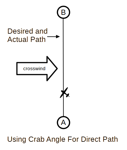
Project #3
Definition: crab angle or weather cock angle is the angle a pilot turns the airplane into the wind to nullify the effect of a crosswind.
Modify Project #2. What would the airplane's crab angle need to be to have it travel directly from airport A to airport B? How long will it take to get there?
Diagrams
For a description of a generalized solution HERE
For some math hints click HERE
Links
ATSC 113 Weather for Sailing, Flying & Snow Sports
Cardinal direction (Wikipedia)